Those things which are idealistic, if pursued, may in the end be tempered or changed by current facts and forces. Facing those facts and forces, it is the ideal that leads the way forward. Using my best understanding of current conditions, this plan represents my search for a more ideal city.
It has become clear that, without making major cuts to carbon emissions by the end of this decade, we will face a future which is far worse than our past. In face of this reality, we must change. And to change, we must retain hope. We will, no doubt, need to deal with the damage done, but if we are to survive the threat of climate change, we must envision a future where we not only survive but one where we also thrive.
Growing up in the suburbs. I took part in the “American dream”. It was a happy life. I have found for myself a different American dream in my adult life living in the inner city. With easy access to work, downtown amenities and abundant greenspace it is also a very happy life.
Living in the city core may not be the right choice for every individual or family, but it could be the right choice for a lot more people than today. The carbon footprint of a family living in a multifamily building in the middle of the city is significantly less than a family living in a single-family home in the suburbs (even with remote work).
The downtown Minneapolis residential population now stands at 50,000. The city’s twenty-year goal was to increase that number to 70,000. Over the next thirty to forty years, I believe we should aim beyond that number and look to increasing the downtown population to something closer to 100,000, and perhaps more.
Making this happen is a matter of promotion, planning and investment. Promotion, because most Americans are not familiar with urban living and may not understand the benefits. And planning, because today not enough of downtown serves as a habitable neighborhood where individuals and families can go about their lives.
Work on this will involve the central business district where some office buildings will turn to residential and other uses because of the move toward remote work. It would be a mistake however, to believe that most new residents to downtown will want to live in the middle of the towering central business district. To grow downtown’s residential population and to keep downtown as a preferred homebase for businesses, I believe we should look to further redevelop downtown’s industrial zoned edges. The east side along the riverfront has been redeveloped. It is now time we should look at the west side.
Downtown Minneapolis is blessed with a dense central business district. That dense central business district is blessed by close proximity to surrounding high-density mixed-use neighborhoods with important institutions and exceptional public open spaces. The greatest growth in downtown residential population over the past twenty years has taken place in this area around the edges of the central business district.
The riverfront, once the city’s premiere industrial district, in its declining years, served as a barrier between downtown, the river and the neighborhoods beyond. Redevelopment of the district’s historic buildings, infill sites and the district’s large empty spaces has benefitted downtown and the entire city. The riverfront still retains some industrial uses, but it is now a neighborhood because of the cohesive walkable environment established by redevelopment.
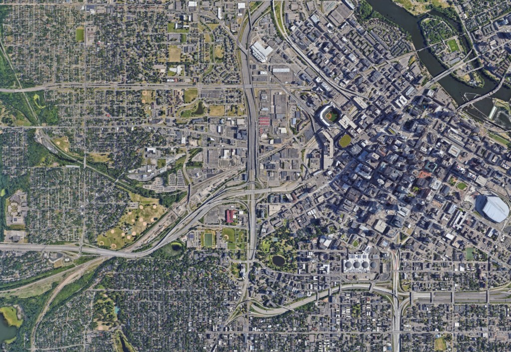
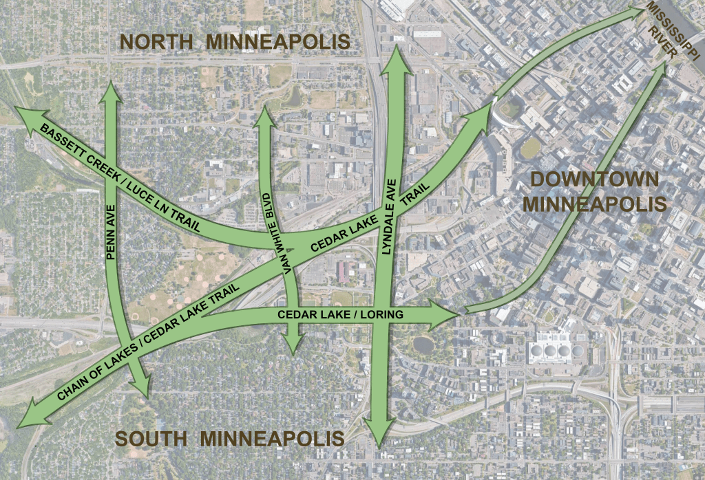
The west side of downtown Minneapolis is both similar and different from the Mississippi riverfront. Both have had a mix of industrial buildings and rail yards. Few historic buildings remain on the westside. On the east side the rail yards ran parallel to the river and the edge of downtown. On the west side they run west, away from the downtown core. There is also the natural attraction of the river. There is no Mississippi on the west side. There is, however, an outstanding network of parks that connect to the city’s regional parks, including the Chain of Lakes and Theodore Wirth.
And last, of course, are freeways. No freeways run through the downtown riverfront. On the west side, with I-94 and I-394, they dominate. Like the railroads built before them the key to the success of
today’s freeway system is its exclusivity. Whether for the passage of trains or automobiles, the infrastructure that serves them is a closed domain serving uninterrupted travel. It is also a closed domain – like a wall – in that it creates hard divisions from one side to the other. The key to a successful city, on the other hand, is a street and pathway system that is largely inclusive and accessible. Because of this, a place where there should be a major confluence of the city’s great public open spaces, and, a place where north and south Minneapolis meet, the west side is instead, a place where the city fabric is utterly broken.

The result today is that the quality of public space here is diminished by tenuous and unattractive connections between each of the open space features. The result too, is that much of the west side of downtown Minneapolis is unused or underused. This area, I believe, has the capacity to accommodate a lot more homes and businesses. Just like the riverfront, I believe redevelopment here will benefit surrounding neighborhoods with improved access to parks, adjacent neighborhoods and downtown.
And, Downtown will benefit by completing its transformation into a fully post-industrial 21st century downtown, a downtown that serves as a complete live-work-play campus, a neighborhood.
PLAN FRAMEWORK
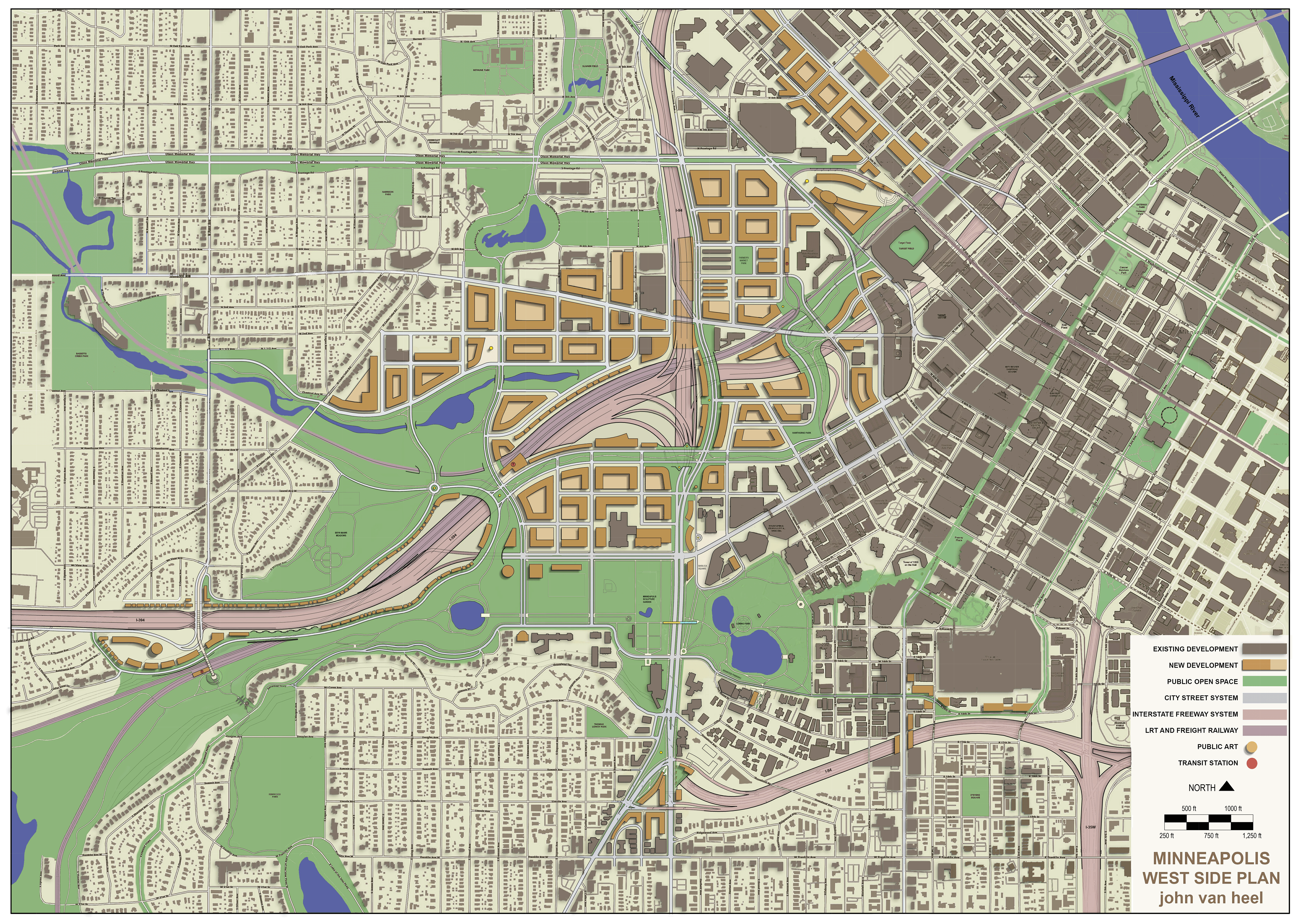
The Minneapolis West Side Plan is built around important existing city streets and open space corridors. Each of these are negatively impacted by the existing freeway and rail corridors. The plan is offered as one iteration of how to repair and strengthen each of these city-based circulation features.
PLAN FEATURES
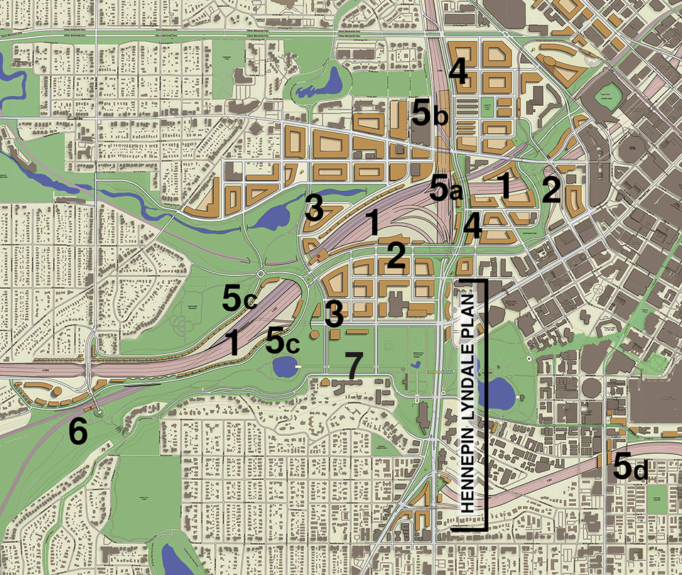
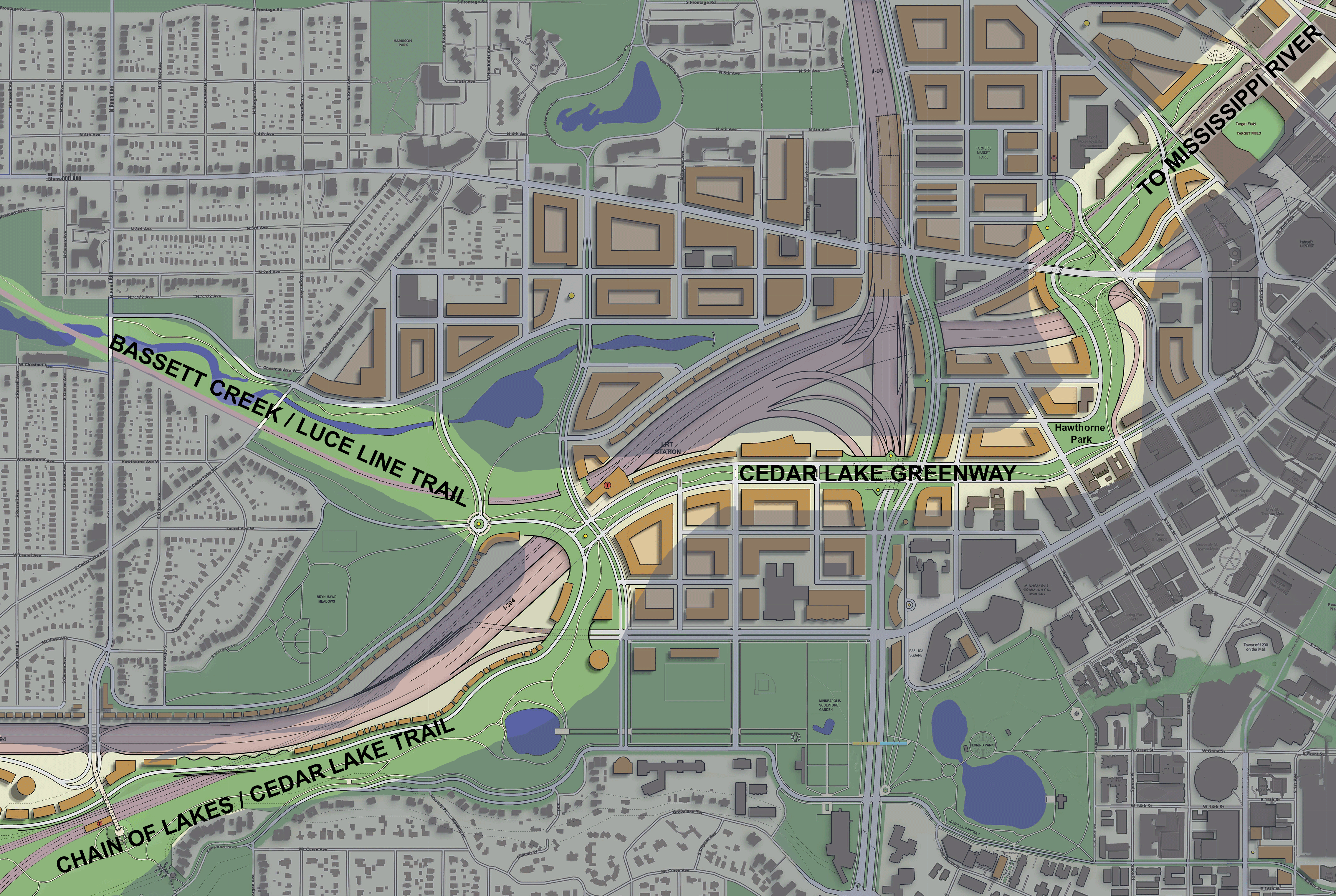
2. Cedar Lake Greenway
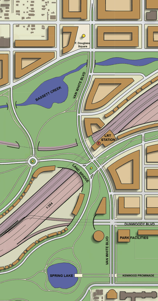
3. Van White Boulevard and Land Bridge
4. Lyndale Ave north-south connection
5. Freeway Liner Development
6. Bryn Mawr – Kenwood Pedestrian Connection 7. Kenwood Promenade
Plan General Notes
1. This is a scaled concept plan with varying levels of detail. My intent has been to find workable solutions that address the physical conditions that are present. Many questions remain.
2. It is assumed that, in the time 20-to-30-year time frame needed for rebuilding the west side freeway infrastructure, the country will have largely transitioned to electric vehicles. Pollution from particulates will remain an issue near these roadways, but vehicle exhaust will not.
3. This plan assumes I-94 and I-394 will remain as major metro and state serving high-speed transportation arteries. Turning either into city boulevards will remain impractical.
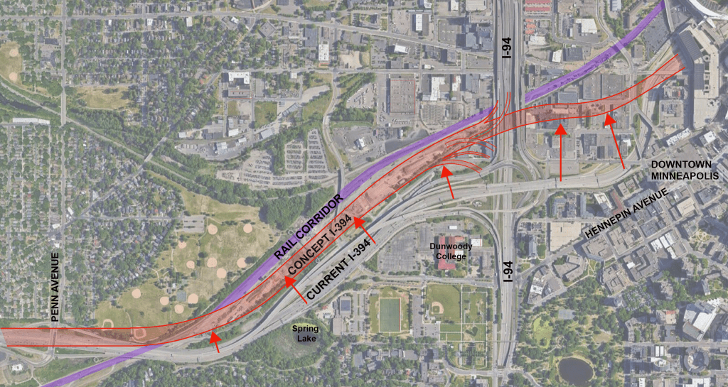
1. I-394 Realignment
The Cedar Lake Bike Trail east of Penn Avenue currently runs along the north side of I-394, a largely unused space where a rail yard used to be. It is an unattractive and isolated space with nine lanes of elevated freeway on one side and an active freight rail line and future LRT line on the other. It is no wider than the nine lanes I-394. Current planning that shows new development in this mostly unused space (Linden Yards) would help the bike trail, but, because the area would remain an island, I believe it would be less than ideal.
Instead of developing this space, I think consideration should be given to building a realigned I-394 here. Bringing the freeway and rail lines into closer alignment provides better opportunities to connect the urban fabric at this major dividing line between north and south Minneapolis.
In addition, it would open up a significant amount of valuable urban space where the freeway is currently located. The benefits of this could include:
• The possibility of having a more visible and spacious park connection between the Cedar Lake Trail and Kenwood Parkway.
• Instead of having an elevated freeway run within 20 feet of the north shore of Spring Lake, as is currently the case, there could be additional park land there. This would protect the lake’s water and open up other opportunities for park space improvements.
• The opportunity to develop a new neighborhood area north of the Minneapolis Sculpture Garden utilizing Dunwoody College’s vast surface parking and the additional land provided by moving the freeway.
Realignment of I-394 may or may not include moving the I-94 / I-394 interchange. Keeping the interchange where it is located now would reduce newly available land to the south. In this plan I show the interchange shifted north so that the realignment of I-394 continues east, past I-94 going into downtown. This part may be ambitious. It is certainly no more ambitious, though, than the planning and work that was done to put the freeway where it is the first place.
Currently, this eastern portion of the freeway runs barely more than one block from one of the City’s most important streets, Hennepin Avenue. Ideally, a street like this should have mixed use neighborhood areas on both sides of the street. A single block does not make a neighborhood. Places located along the north side of the street, all the way west to the Basilica of St. Mary, lost their surrounding neighborhood areas when the freeway went in. The city would benefit by regaining this lost territory. Additional Thoughts
2. Cedar Lake Trail and Cedar Lake Greenway
The current Cedar Lake Trail does benefit in one way by running in between the freeway and rail lines in that it is uninterrupted by streets. One could realign I-394 farther north while keeping the trail in the same in-between place in relation to the freeway and railroad. This would require the trail to pass underneath the freeway as it does today. In West Side Plan the trail would instead run through the newly available park land on the south side of the freeway where it would then run through a new “Cedar Lake Greenway”, that would connect to the existing North Loop section of the trail which connects to the Mississippi Riverfront.
While this new route would involve a handful of bike trail street crossings, because of it’s more visible and accessible location, it would, I believe, provide a safer and more beautiful route which would better serve the surrounding neighborhoods.
3. Van White Boulevard and Land Bridge
The I-394 freeway and rail corridor are the cause of a severe break between north and south Minneapolis. Currently, Van White Blvd, along with Lyndale Ave and Penn Avenue, are the only city streets that cross the divide in the mile long stretch running west from downtown. Each of these crossing points are a pedestrian no man’s land. At Van White Blvd the roadway runs underneath eight lanes of freeway.
There are times when running city streets underneath freeway infrastructure is necessary, but it is not ideal. City streets, I believe, generally should be open to the sky and run over the top of the freeway. The same is the case for when there is a desire to join significant landscape features from one side to the next. There are multiple examples of landscaped land bridges in Minnesota. Building one here over a rebuilt freeway could draw together a more contiguous open space between Kenwood Parkway, the Cedar Lake Trail, the Chain of Lakes, Bryn Mawr Fields, Bassett Creak and Theodore Wirth Park.
4. Lyndale Ave North-South Connection
Stretching from the city’s far north to its far south, Lyndale Ave is an important line of connection for our north-south oriented city. When it joins with Hennepin Ave southwest of downtown (see Hennepin Lyndale Plan) it runs through an area with some of the city’s greatest institutions and public spaces.
Once Hennepin splits off into downtown everything falls apart for Lyndale. It is absorbed into freeway dominated infrastructure until it reaches Plymouth Ave., over a mile to the north. This plan does not extend that far (I recognize my Loring Park-centric point of view). It does, however, reach for the ideal of making Lyndale a complete city street again from Hennepin Ave to Olsen Memorial Highway. Doing this would, I believe, help knit back together Minneapolis’ north and south sides.
Currently, the roadway splits at Hennepin near the Basilica of St. Mary, with northbound lanes running to the east of I-94 and southbound lanes running to the west. It does this across the I-94 / I-394 interchange. The goal of the plan was to disentangle the street from the freeway. In order to do this, both lanes in the plan sweep together around the east side of the freeway interchange. This is helped by the fact that the interchange primarily serves movement between north-south and west directions. The section of I-394 running to the east of I-94 is intended for I-394 downtown access. Access to this section of freeway is currently limited from I-94. Preserving this relationship, this plan shows the freeway functions confined to the west side of I-94. This allows land on the east side to become available for development along a new Lyndale Avenue.
With the desire to make the street a fully functioning city street, having buildings on both sides would be ideal. For this purpose, the plan at Lyndale incorporates three of four types of freeway liner development that I have investigated. See types A, B and C below.

5. Freeway Liner Development
We are looking at a future where automobiles are likely to be a lot cleaner, quieter and safer. How close can we build around the edges of the freeway? Some stretches of American freeway have broad landscaped shoulders and service roads. Some, like most of I-94 and I-394 on the west side of downtown, have neither. There are many current examples of buildings located in near proximity to freeway edges. I believe development that lines the edges of freeway infrastructure can help to heal the damage the freeways caused to the city. I have investigated four types of freeway Liner development.
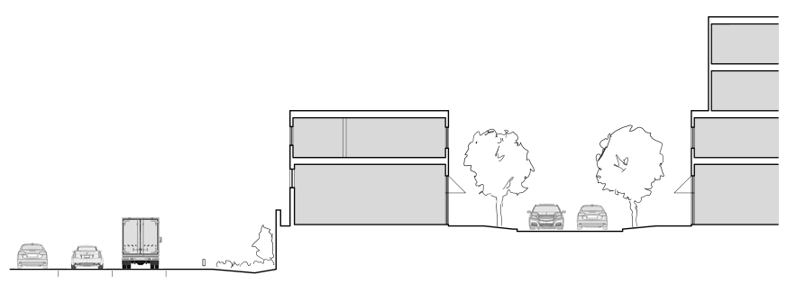
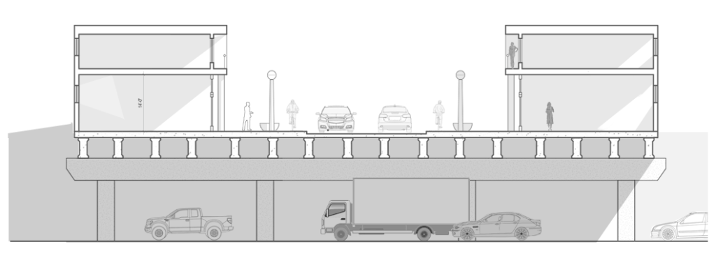
A. BUILDING EDGE TO FREEWAY EDGE LINER DEVELOPMENT – Where the back face of a building sits on or close to the line of acceptable proximity. Residential development, I tend to think, would not be the best suited use for this configuration. However, for other uses such as commercial and light industrial uses it could work well.
B. UNDERSIDE FREEWAY LINER DEVELOPMENT – Limited sections of elevated freeway cannot always be avoided. Underside Freeway Development, which utilizes the empty space beneath an elevated freeway, is a way to establish street-front form and street front uses when there is no available land between the freeway and an adjacent street. In this plan I envision the area around the historic

farmers market at Lyndale Ave and Glenwood Ave as an expanded retail district. The open air market would be framed by storefronts instead of the dark shadows cast by today’s elevated freeway.
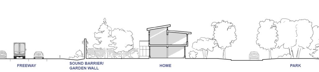
C. GARDEN WALL FREEWAY LINER DEVELOPMENT – Used where there are greater light and air needs by occupants, such as residential buildings, this type of development, along with the similar Garden Wall Railway Liner Development, is located in the western half of the plan where green spaces adjoin the freeway.
Today, when I look east across Bryn Mawr Fields Park toward the far edges where the railway and freeway are, my impression is that I would tell my children not to go there. I would prefer to look across the park and see, instead, houses or multifamily homes. That would make a safer and more ideal edge for a city park.
As automobiles become cleaner and quieter, putting the backyards of new homes up against a freeway sound wall (garden wall) may not only be viewed as an acceptable option, with a front yard facing a beautiful Minneapolis park, it could be highly attractive.
Not only would building along the edges of freeways provide an urban face and a screen to the freeway and rail lines, it would also provide an opportunity to rebuild the local roadway system that was interrupted by the rail and freeway infrastructure. Smaller local roads serve cars, bicycles and pedestrians. Building new roads along these rough and unused park edges could help better connect the park system and city neighborhoods.
D. CROSS-FREEWAY LINER DEVELOPMENT– The last type of freeway Liner development I envision in the west side plan is Cross-freeway Liner development. Sometimes reconnecting the urban fabric across a freeway is not a matter of recovering large acreage but rather reconnecting two sections of a street and street frontage. There are a couple locations on the plan where this type of development is shown. Perhaps the best example is located outside the west side area, farther south where I-94 bends to the east at Nicollet Avenue. The Steven’s Square Neighborhood, located south of I-94, was considered part of the Loring Park Neighborhood before the freeway went in. In addition to cutting the neighborhood in two, the freeway cut in two the vibrant Loring Nicollet commercial district that ran from Grant Street to Franklin Avenue. The windswept Bridge and adjacent vacant lots where buildings were demolished to make way for the freeway created a devastating hole in the very center of the six block long district. Recent development has helped narrow the hole.
While a new bridge with better, wider pedestrian accommodations would be an improvement, continuing the storefronts across the freeway would be the ideal. It works best where the bridge crossing is fairly level.
An example (right) of street edge retail development over the top of an existing freeway in Columbus, Ohio. Additional Thoughts

6. Bryn Mawr – Kenwood Pedestrian Connection
This is the most westerly location in the plan and the last place I have attempted to envision a stronger connection across the city’s great north-south divide caused by the east-west I-94 and adjacent rail corridor.
Penn Avenue currently stops just south of I-94. There is a significant drop in elevation down to where the LRT line and Cedar Lake Trail is. Farther south there is an even more significant change in elevation going up to the top of Lowry Hill in the Kenwood neighborhood. I am not so ambitious as to imagine a bridge extending Penn Ave south to Kenwood. It is unneeded in this largely residential area. My focus here was on pedestrians. The biggest difficulty is at Penn Avenue and I-94 where there is a major interchange between the city street system and the freeway. Because walking across the start of a freeway on or off ramp is inherently more dangerous than crossing a typical city street crossing the freeway on Penn Ave. presents an unsafe obstacle for pedestrians. After the S.W. LRT line and the associated LRT station open, the issue will worsen as more pedestrians cross from Bryn Mawr.
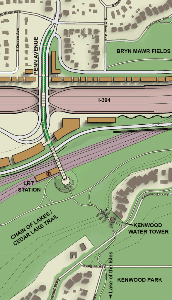
My solution was to create a pedestrian walkway that would run down the center of Penn Avenue. The walkway rises up to the center of the bridge where it passes over a cross-traffic intersection for freeway on and off ramps. The walkway then goes down and across the rail corridor to the LRT station now under construction.

To connect to the Cedar Lake Trail and up to the top of the ridge where the Kenwood neighborhood is, I imagined a dual set of stairs and ramps that would look to each other across the ravine. One set would come down next to the historic Kenwood Water Tower. The other, in the form of a cone-shaped pyramid, would come down from the Bryn Mawr side at the bridge to the LRT station. I see it as a park and recreation celebration of stairs and ramps – running from the top of one side to the top of the other side a few times over would be great exercise.
7. Kenwood Promenade
If I-394 were realigned farther north adjacent to the rail corridor, pushing it away from the shore of Spring Lake (a pond, but no less beautiful), it would be much more reasonable to make it a park feature that people could walk around and experience.
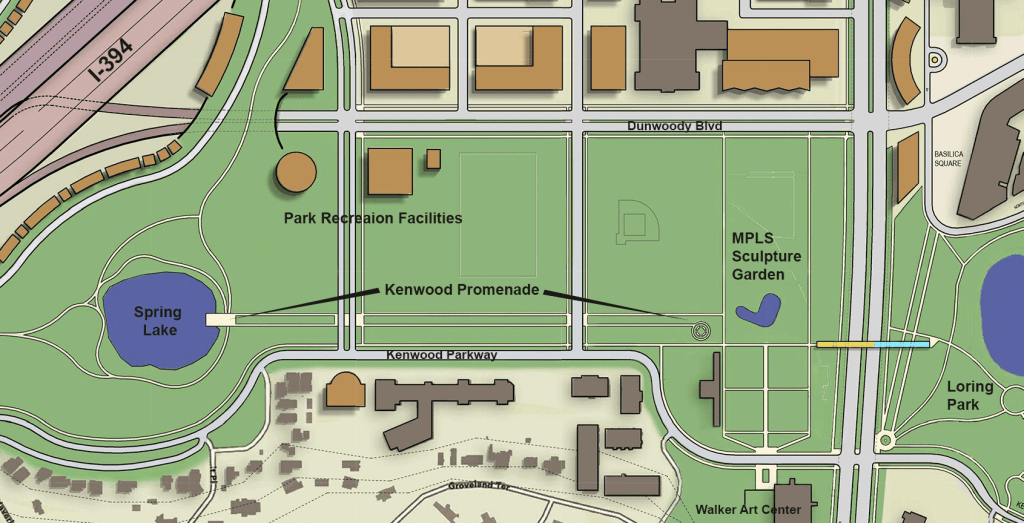
Heading out on summer bike rides to the Chain of Lakes from my Loring Park neighborhood home, I pass by Spring Lake on Kenwood Parkway after crossing Loring Park and the Sculpture Garden. I can travel for miles and I never have to leave the Minneapolis park system.
Unfortunately, I don’t think a new visitor to the Minneapolis Sculpture Garden would have any idea of the vast green spaces that lead off to the west of the Sculpture Garden. A path to the west is visible, but is off to the side of the of the sculpture garden center open space and is cramped by surface parking. The promenade, like a green tree-lined street for pedestrians, would create a clear path and gateway to the rest of the park system to the west.
Doing this would not necessarily require building a new Parade Ice Garden farther north as I’ve shown in the plan. As a concept plan, this and other park recreation facilities are show located along Dunwoody Blvd. The football field and parking would have to be pushed a little farther north to establish a more substantial linear green space between the sculpture garden and Spring Lake.
ADDITIONAL THOUGHTS & INFORMATION
Minneapolis West Side Plan Intro – Additional Thoughts
The industrial zoned area in the plan identified for redevelopment (buildings colored amber) includes mostly one and two-story office, warehousing, and light manufacturing facilities. The HERC (Hennepin Energy Recovery Center), which burns trash and turns it into electricity, is the only existing facility here that presents a significant pollution concern (not sure about affect of large diesel trucks).
In terms of relocation of valued businesses in the area if the area were to be redeveloped, it appears to me that the HERC would present the only significant issue related to avoiding negative environmental impacts of potential relocation sites and their surrounding communities. It should be noted though, that this form of trash disposal and energy creation is not a favored direction for the future. A most likely option would seem to be that it simply goes away, being replaced instead by several alternate methods already in place elsewhere.
Regarding the effects of redevelopment on impacted communities of the Near Northside, significant community engagement and planning would need to start early in the planning process in order that the current community members are protected from harm and instead benefit to the fullest extent possible.
I-394 Realignment – Additional Thoughts
I recognize that realigning I-394 is perhaps, too big a goal given where we are with current planning for development near the future Van White LRT station (in the sliver of land in between the rail line and the freeway). Given that this whole area is largely vacant, I think it is still worthwhile to step back and think big. If the freeway stays put, can the framework of streets and open space corridors described in the ‘Plan Framework’ diagram be improved in a substantial way? I’m not sure, but I would like to see that plan too. I haven’t seen it yet.
Throughout the plan I have tried to incorporate freeway configurations that reduce the freeway’s footprint. This includes the I-94/I-394 interchange where some ramps lift up from a center lane rather than pushing out to the side from an outer lane.
Another example is shown at Penn Avenue where on and off ramps would push out to the sides of the freeway but then come back over the top of the freeway with left turning lanes at the center of the bridge where there is a traffic light-controlled intersection. While I have done some examination of slopes, distances and radii, I am no engineer, and this part remains at a concept sketch level.
Cedar lake Greenway – Additional Thoughts
The Cedar Lake Greenway includes two land bridges that would require significant earth work. In this case it would be the work of building up land. Similar to the land bridge that goes over LaSalle Avenue at the Loring Greenway in the Loring Park Neighborhood, the land leading up to the land bridge is built up at a slope to go up and over the street below.

– If I-394 was realigned north to abut the rail line, an alternative bike trail route to what I show as the Cedar Lake Greenway could pass along the north side of the rail and freeway corridor. Back
Freeway Liner Development
The details of how to do development along the edges of freeways and rail lines would need further investigation. I’m sure some access easements to would need to be added. Establishing what the acceptable proximity of development to the freeway and rail line would require further study and discussion. Building in proximity to rail lines is could present safety issues. It should be noted however, that the rail line shown in the plan goes through the heart of the Warehouse District where there are multiple buildings, including residential buildings, that are currently in very close proximity to the rail line. It is a current issue that needs to be addressed.
Bryn Mawr – Kenwood Pedestrian Connection – Additional Thoughts
This portion of the plan is the only place I am aware of that I have removed existing homes. Two homes were removed just north of I-94 and east of Penn Ave. As a concept plan I did this to carry through the garden wall liner home concept. The removals were not necessary for the I-394 realignment in the plan. On the west side of the Kenwood Water Tower there are two homes I am showing as physically moved to more spacious sites on the vacant land several hundred feet farther west on the ridge. I did to provide more public space at the water tower and stairs/ramps down to the Cedar Lake Trail.
