Over the past 15 years, through multiple planning processes, from residents and institutional leaders alike, I have heard how people care about this traffic-packed corridor. Seeing the important religious, cultural, and public space institutions here, there has been an ongoing desire to see the physical environment here once again match the civic nature of the surrounding buildings.
Work to make this happen has mostly focused on near-term improvements that work within the context of the existing freeway infrastructure. It has also happened through the work of envisioning longer-term change that involves more significant alterations to the freeway infrastructure. I have always believed both are important and can happen at the same time. Neglecting near-term issues does not advance long-term goals. Like the Rondo community in St. Paul, I think it is instead, by establishing a history of caring, that bigger dreams can be achieved. Serving in community leadership roles, including for city-funded projects, I have felt a chief responsibility to focus on opportunities that were present in the near-term. Even near-term efforts can take years of work. I’m proud of the improvements that have been made at Hennepin Lyndale.
That said, the need for bigger long-term changes at the Hennepin Lyndale corridor remain. I have seen the concepts and taken part in the discussions on the future of the corridor. I have come to my own vision. As time continues to pass, it is now the long-term to which I turn my attention in this website, and in this plan.
Hennepin Lyndale Overview
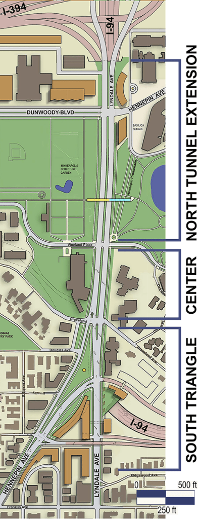
There are three distinct parts of the Hennepin Lyndale Corridor. The south end, center section, and north end. The center section sits on top of the I-94 Lowry Hill Tunnel. It is lined on each side by existing buildings with architectural and civic importance. This stretch has not called for dramatic physical changes, rather, attention to the urban and pedestrian details that make a successful city street. The trees, lighting, improved walkways, and upgraded maintenance that resulted from the 2015 Hennepin Lyndale Reconstruction Project brought this section a long way closer toward people’s ideal, but the corridor, as a whole, remains a disappointment to most people. Bigger changes have been called for at the north and south ends.
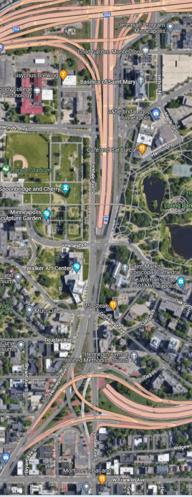
Some concepts and vision statements over the years have focused on the south end, what I call the South Triangle. This area today is occupied by the elevated on-ramps and off-ramps of I-94 (the Spaghetti Bowl). The other area of focus runs north from where I-94 emerges from the Lowry Hill Tunnel. It passes between Loring Park and the Minneapolis Sculpture Garden. In my plan I call this the Lowry Tunnel Extension area.
Those that have looked at the south end have rarely looked also at the north end. The opposite is true for those who have looked at the north end. This is alright, as each, I think, represent independent projects that could happen at different times.
This description of the plan is broken into these two parts. Before going into the plan description, however, it is important to provide a brief history of the place where Hennepin Avenue and Lyndale Avenue come together.
A Brief History of Hennepin Lyndale
Most are familiar with what a mountain pass is. There are also passes that traverse smaller ridges. Hennepin Lyndale is located at a pass that goes up and over the mile and a half long ridge that we know today as Lowry Hill. Today the ridge appears to have a relatively flat top. When the city was platted in the 19th century the high points along this ridge, which was once known as the Devil’s Backbone, were cut down to fill in low points. The low point at Hennepin Lyndale (which was not filled in) had a broad approach that made it an easiest and most logical path for animals like buffalo, and people, to go to and from the lower ground on the north side and the higher ground on the south.
This pass is now shared by two roads. One, the northeasterly to southwesterly path of an ancient Indigenous trail (today’s Hennepin Ave) which connected Bde Maka Ska to the great waterfall at the Mississippi River (St. Anthony Falls). And the other, the north to south Lyndale Ave which was a development of the four-point compass-oriented street grid that was established around the city’s core.
Because of this ridge, the next north-south Street that crosses the ridge to the east is LaSalle and Nicollet Avenues, six blocks away. To the west, there are none as far as the city’s west border where the ridge has drops away at Cedar Lake. Because of this the Hennepin Lyndale corridor serves as the primary link between downtown and the large southwest part of the city. This equates to a lot of traffic (never mind I-94 running in the tunnel below).
Like Broadway Avenue in Manhattan, which also had Indigenous origins, Minneapolis’ Hennepin Avenue cuts at an angle across the city grid’s dominant north-south running avenues. This made for interesting buildings and urban spaces, but very difficult intersections to negotiate. Over a century ago the conjoined term Hennepin Lyndale was born along with a descriptive: The Hennepin Lyndale Bottleneck.
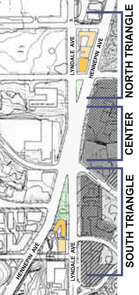
Hennepin and Lyndale Avenues intersected on the north slope of the ridge in between Groveland Ave and Vineland Place. To the north and south were triangular shaped blocks with distinctive wedge-shaped buildings. The north triangle block started where I-94 exits the Lowry Hill Tunnel today. The South Triangle started at Douglas Ave., south of the Lowry Hill Tunnel. When the freeway went in, the south triangle was replaced by freeway on-ramps and off-ramps. The north triangle was replaced by the freeway itself.
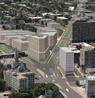
South Triangle Plan
Because the South Triangle area today is not occupied by the freeway itself, the common desire has been to remove the freeway on ramps and off ramps and replace them with something more in context with the pedestrian suitable urban fabric. Two general concepts have arisen. The first is that of a large traffic circle that would channel connections between Hennepin, Lyndale, and the freeway. This concept, first put forward in the MnDOT 2007-8 Downtown Freeway Study, dominated early community discussions going back to the same period. See Hennepin Lyndale Charrette
In 2013 when planning was underway for the Hennepin Lyndale Reconstruction Project, illustrations of the other option came forward in community discussions from Joe Polacek, which was the idea of Restoring the Street Grid. I believe this second option is superior.
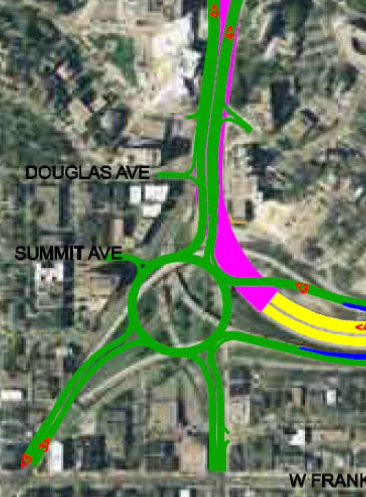
Comparing traffic volumes at Columbus Circle in New York and Hennepin Lyndale, it appears a traffic circle (like a roundabout but with some traffic lights) could be a workable alternative to the flyover ramps that are there now. It would indeed be possible to create a beautiful green space with a great work of art in the middle of a traffic circle here.
My objection to a traffic circle though, is that there would be no surrounding built form to reinforce the geometry of a traffic circle. The great urban traffic circles of Europe have surrounding buildings that form tight circular or complimentary square outdoor “rooms” that support and accentuate the circle. Unless one were to replace some of the surrounding buildings with new development in order to work with the circular vision, a grand traffic circle here would not be the reality. Instead, it would, I think, be an area of roadway that, not unlike what is there today, would feel disconnected from the urban fabric around it. In the game I play (admittedly) when making these plans, there are self-made rules. It is all a matter of what should be preserved and what might, or should, change. In almost all circumstances my rule is that existing historic and affordable housing is preserved.
Remaking the area around the traffic circle in order to complement the circle does not seem to be feasible. Instead of looking to European grandeur I think we should return to the opportunities inherent in the grid.
Does this mean reproducing the streets just as they were before the freeway went in? No. There is an exceptionally high level of traffic here. In my mind that cannot be wished away. Previous iterations of the street grid concept See Bottleneck Overview S. Rockwell did not go far enough in addressing high traffic volumes. To do this the grid needs to bend and stretch in some places. Blocks that are too short and with too many traffic lights would lead to grid lock. In this plan I have tried to minimize the number of traffic light-controlled intersections (one less than now).

The most exciting thing to me about restoring the grid is the opportunity to rebuild important elements of the historic fabric, namely, the wedge-shaped south triangle block. Looking south toward this area today the city seems to fall away into the directionless hole that is the “spaghetti bowl”. Lyndale Avenue and Hennepin Avenue to the south (Uptown) is utterly disconnected to Hennepin Lyndale to the north at Loring Park and the Walker Art Center.
This is very different than a place like Madison Square in New York City. Looking south down Broadway toward the famous Flatiron building, you see a dynamic form that tells us in a beautiful way that a significant event is happening to the street grid ahead. It’s splitting in two. Filling the void that is the spaghetti bowl will reconnect the north and south portions of
these streets and will mean the splitting roadways here will once again become physically manifest. It is an opportunity for a signature building.
I am no lead designer, but for this one site I could not resist exploring the built form possibilities. The impression in my mind was of a mixed-use residential development. I’m afraid what I came up with looks a little more (too) corporate. If given more time (and with more modeling skill) I would develop something with richer textures and fenestration patterns. The site seems to ask for a building with a big sweeping gesture. I think of historic examples like the sweeping roofs found in some 19th century Shingle Style buildings, and in some modernist buildings too. I’d love to see what a Bjarke Ingels would do here. I would love to see what others would do here. Period.
The south triangle site does have one difficulty that would need to be addressed in any future development: Access. Deliveries, move-ins, drop-offs all require vehicles to turn into building driveways. With high traffic volumes here, requiring cross-traffic left-hand turns to get to a driveway would become a major cause of traffic backups. Restricted one-way drives could work. In this plan I have made one access point to the site using a traffic signal at the Lyndale Ave. entrance to I-94.
In addition to looking at development possibilities at the South Triangle site, I also looked at the land just to the east where the I-94 tunnel is. While there are spaces to either side of the freeway that are big enough for development, access is a problem here too. The solution I imagined in the plan was for these buildings to be connected by tunnel or skyway to associated adjacent developments that were better suited to having curb cuts and driveway access.
North Triangle & Lowry Hill Tunnel Extension
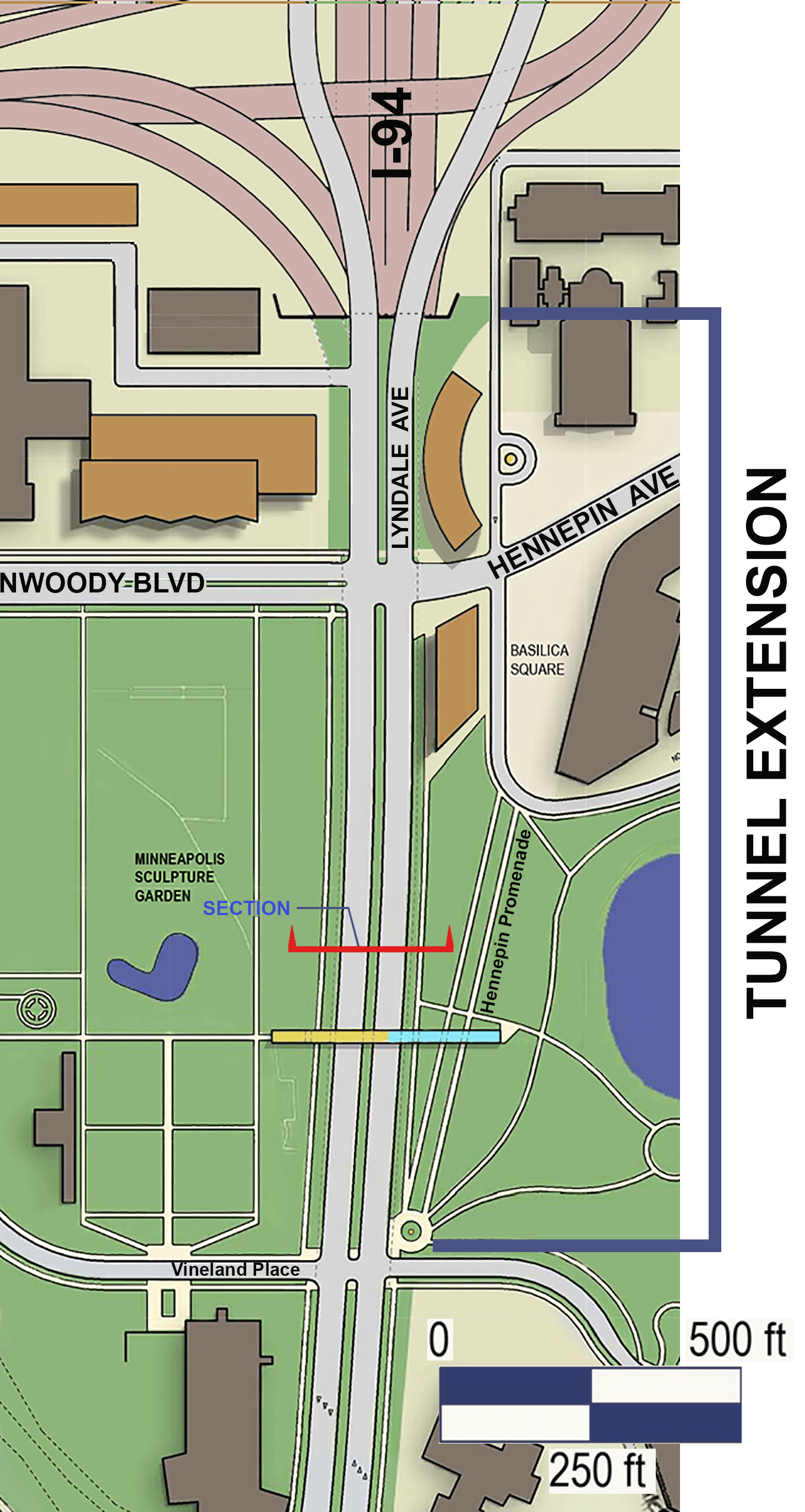
The North Triangle today presents a very different situation than the South Triangle. Where a noted wedge-shaped hotel once stood the I-94 freeway now makes its exit from the north end of the Lowry Hill Tunnel. It is here that the north and south bound lanes of Hennepin Lyndale divide, going along the east and west sides of the freeway. Spread out, the freeway and city roadways together create a wide expanse of concrete and fast-moving vehicles. Looking north from Vineland Place, the view toward the Basilica and far off to the west is that of freeway infrastructure enveloping the horizon.
While I have played with the possibilities here and considered the associated issues, unlike the South Triangle, for which the general solution has been clear in my mind for some time, the stretch to the north has been less clear. It would be a significantly larger infrastructure project than the south triangle. The vision long expressed by the community has been to extend the Lowry Tunnel north. How to do that, and how far to extend it has never been well defined. Rough sketches are a start, but to get deeper into issues and options, more detail is required. That is what I am trying to offer in this plan.
There have been three different goals in the ideas related to extending the Lowry Hill Tunnel. The first goal is to strengthen the connection between Loring Park and the Minneapolis Sculpture Garden. The second goal has been to remove the significant negative environmental impacts the freeway has on Loring Park and the Minneapolis Sculpture Garden (noise, salt, particulates, visual disquiet). The third goal has been to restore the urban fabric that is just to the north of Loring Park and the Minneapolis Sculpture Garden.
The first goal of making a stronger connection between Loring Park and the Minneapolis Sculpture Garden comes out of the current
perception that they are already part of one contiguous open space as defined by the buildings that surround them. Interestingly, it was the act of removing the buildings that sat above where the freeway emerges from the Lowry Hill Tunnel that established the perceived connection between the Loring Park space and the open space that would become today’s Mpls Sculpture Garden. In the stretch that runs between these two spaces Hennepin, Lyndale and I-94 is relatively low and is not lined by buildings. Because of this the two spaces are visually connected across the roadways. At the same time, because the size and nature of the combined arteries of Hennepin, Lyndale and I-94, there is also a strong and unpleasant perceived divide.
While I can imagine a workable scheme where a new wedge-shaped block of buildings would be built on top of the freeway where the North Triangle once stood, in this plan I have chosen not to recreate this block of buildings, which if done, would recreate a physical separation between Loring Park and the Sculpture Garden. I have long admired the exceptional interconnectedness of the Minneapolis park system. Further fusing these two public spaces together will help form a greater “Central” park that, instead of being enclosed by the city on all sides, would have an open west end leading off to our city’s lakes and forested spaces. A Jeffersonian vision (U of Virginia plan)? Yes. It is hard for me not to have had this vision, having lived for years ten floors up on the east side of Loring Park.
Regarding the third goal, rebuilding the urban fabric located north of Loring Park and the Sculpture Garden, the focus has been the area centered on the Dunwoody Blvd underpass adjacent to the Basilica of St. Mary. This major gateway into downtown is today a dark and foreboding tunnel. Efforts to bring light, color and art to this space have so far failed. The plan I present is for the future. In the meantime, light, color and art are still badly needed here for the now.
Plan Options
As with the South Triangle area, I have been drawn to historic street and block patterns when thinking about a future tunnel extension. However, with the imposition of the freeway, options that diverge from the past have come forth. One idea that community members have discussed is a landscaped land bridge connecting Loring Park and the Sculpture Garden. While this is conceivable, the implication that the land bridge would not only bridge over I-94 but also Hennepin and Lyndale, is for me, problematic. I have tried to pay attention to the hierarchy of street types. The most basic intent of the larger plan is to pull the city-based street system apart from the more inhuman freeway-based system.
In order for Hennepin and Lyndale to go down under the land bridge and then back up again, a land bridge would also involve ramping and retaining walls. With the assumption that these two streets would connect (intersect) with the east-west streets at the north and south edges of Loring Park and the Sculpture Garden, the ramping and retaining walls would all need to happen within the realm of the two park spaces. Using maximum roadway slopes, I estimate approximately 400 feet of roadway would be required,
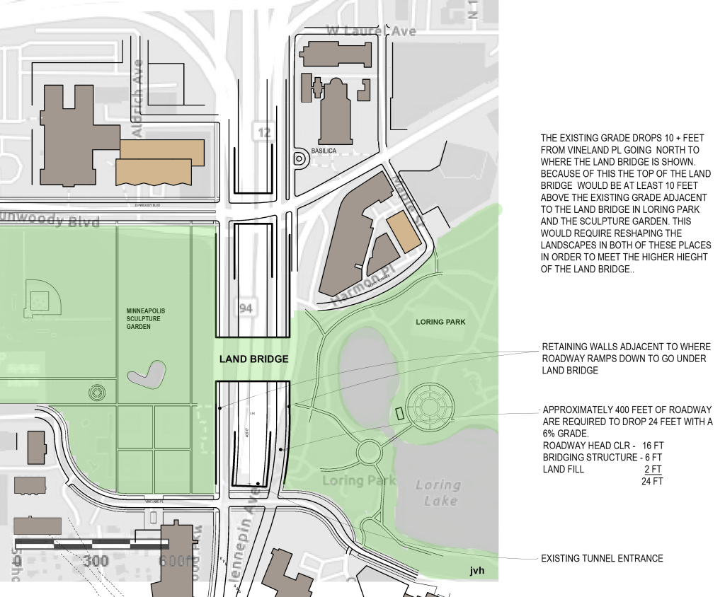
both for going down and coming up. This restricts where the land bridge can be located. The overall width of the land bridge also becomes restricted. The land bridge could be lifted up, lessening these restrictions, but doing this would seem to significantly impact the existing landscapes in each park space since the land there would need to be raised-up to meet a raised-up land bridge.
It appears to me that, instead of seamlessly connecting two existing and beautiful public spaces, a land bridge would demand significant redesign of these spaces in order for the land bridge to make sense.
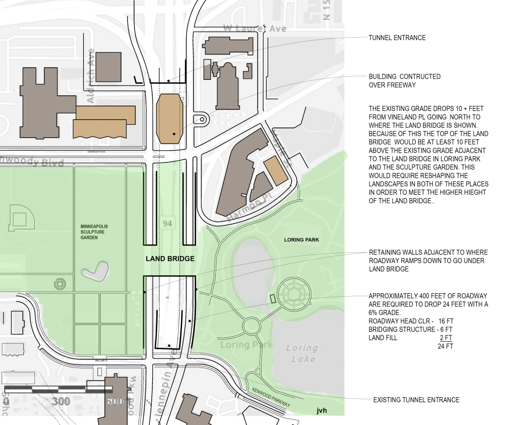
A land bridge is an interesting idea and may be worth further study. I, however, am pulled in a different direction. In this plan I have kept Hennepin and Lyndale above grade.
When considering the extension of the Lowry Hill Tunnel, it should be understood from its name that the tunnel passes through a hill. While its construction was cut and cover, it can be understood to be a true tunnel. Extending the tunnel farther north beyond the hill will instead involve some amount of digging down into the earth, and also some amount of building up of the earth around the tunnel. Avoiding the water table may provide a good reason, cost-wise, for doing more building up than digging down. Fortunately, unlike at the existing tunnel, where there are significant buildings in close proximity to the tunnel’s sides, the stretch to the north, where the tunnel would be extended, is much more open. Because putting Hennepin Lyndale on top of I-94 would free-up land on each side of the combined roadway, the topography could be built up without interfering with significant buildings or existing green space with existing trees.
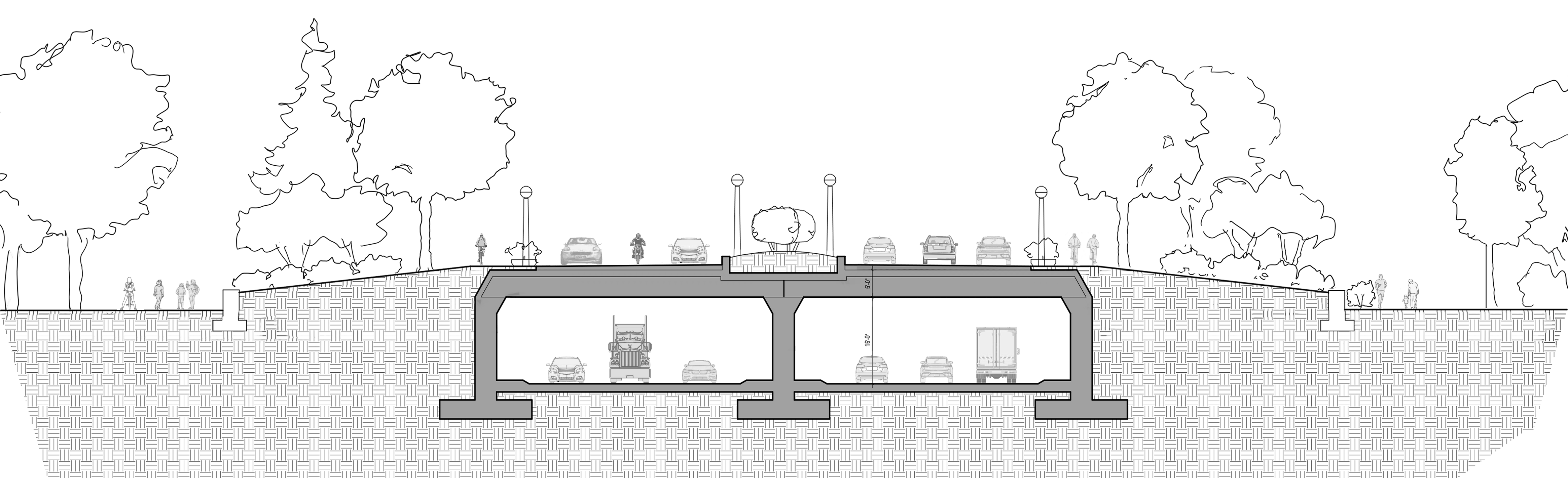
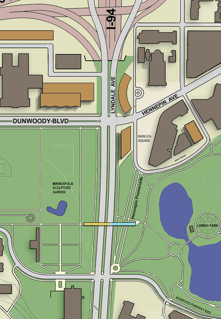
Instead of diverging at Vineland, as they did historically and as they do today, in this plan Hennepin and Lyndale would continue on their parallel route north going directly over the top of a new I-94 tunnel. Adding trees and other landscaping to the entire top the tunnel would require additional structure, additional depth, and additional cost. Keeping the roadways together would also maximize newly available land at Loring Park and the Sculpture Garden.
I occasionally drive and sometimes take transit (Thank you, HOur Car and Metro Transit), but I haven’t owned a car in several decades. My view of the city is primarily on foot and from a bicycle. It is perhaps because of this, I was able give up on the notion of following the historic diagonal course for Hennepin Avenue by replacing it, instead, with a new “Hennepin Promenade” in an expanded Loring Park. The linear open space would align with front of the Basilica, just as the avenue did. I imagine pollinator flowers in the linear open space in between the two walkways rather than grass.
With I-94 underground, a combined Hennepin Lyndale Avenue would still be a busy road that passes through a park. As a city street, this means those using the street should have a pleasant experience of the park. It should also mean there is significant landscape buffering from the street for users of the two parks. Balancing these two needs is done well in places like Central Park in New York.
Even today, additional landscaping along the edges of the freeway would help mitigate the negative impacts on Loring Park and the Minneapolis Sculpture Garden. I’m proud to have helped bring some new trees and shrubs there. A lot more are needed (contribute to the Green Minneapolis Hennepin Lyndale Crossroads).
In my mind, one of the biggest benefits of extending the tunnel would happen on the north side of Loring Park and the Sculpture Garden. Currently, after emerging from the Lowry Hill Tunnel on the south side of the parks, the freeway lifts up and goes over the top of Dunwoody Blvd on the north side of the parks. There is not another city-based street entering downtown for another five blocks to the north at Glenwood Ave., which also enters through the shadow of the elevated I-94.
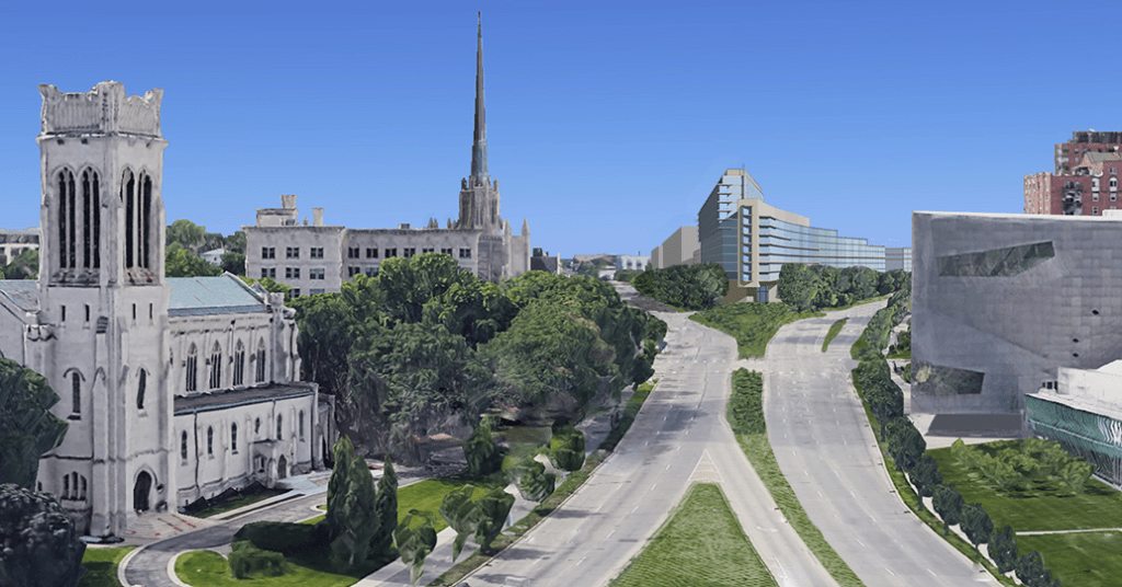
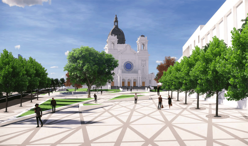
Here at Hennepin Ave and Dunwoody Blvd, stands the Basilica, one of the city’s great classical religious buildings, plus an adjacent block with historic commercial buildings. Even now there is a recognition that the space in front of the Basilica wants to be a public gathering space. Both the Loring Park neighborhood’s 2008 Hennepin Lyndale 15-year plan and the Basilica of St. Mary 2020 masterplan suggest this.
Making this happen in a successful way with the freeway there as it is now would be more difficult.
When going under the Dunwoody Blvd I-94 underpass, you not only pass under I-94; you also pass under an on ramp to I-94 from I-394 and the elevated north-bound portion of Lyndale Ave. With Hennepin Lyndale going over the top of an extended I-94 tunnel, additional space adjacent to the triangular space in front of the Basilica would become available. Some may wish that the space be totally open to the Sculpture Garden to the west.
My sense is that more enclosure to the space would be helpful. For this purpose, I show new buildings along the westside. This, I think, would protect the space from what would otherwise be a wide-open space to the northwest where cold wind could blow. The buildings would also provide a buffer between the space and the high traffic Hennepin Lyndale just to the west. Hennepin Avenue as it heads into downtown would still pass in front of the church, but the area around the church would be a little quieter and more pedestrian with the buffering of buildings. Having buildings on the west side of the open space versus not having buildings there would make the difference between the public space being a plaza or a square. My preference is for a square. I imagine the buildings being no higher than three stories so as not to block views of the Basilica from the west.
And last, there is the question of how far north an extended tunnel should go. If the desire is to remove the Dunwoody Blvd underpass and instead have the boulevard run over the top of an undergrounded I-94, and, if the desire is also to avoid a tunnel exiting right next to the front entrance of the Basilica (with the busy intersection and on / off ramps that would go with it) than the tunnel entrance would want to be several hundred feet north of Dunwoody Blvd.
As I noted earlier, an on ramp to I-94 from I-394 runs over the top of the Dunwoody Blvd. This is part of the I-94 / I-394 interchange. Its tentacles reach as far south as the Sculpture Garden. An extension of the Lowry Hill Tunnel will involve some reworking of this interchange.
When one starts to examine the I-94 / I-394 interchange it is hard not to look out in every direction and see issues and opportunities. This is, in part, the reason for the larger Minneapolis West side Plan.
