1. This is a scaled concept plan with varying levels of detail. My intent has been to find workable solutions that address the physical conditions that are present. Many questions remain.
2. It is assumed that, in the 20-to-30-year time frame needed for rebuilding the west side freeway infrastructure, the country will have largely transitioned to electric vehicles. Pollution from particulates will remain an issue near roadways, but car exhaust will not.
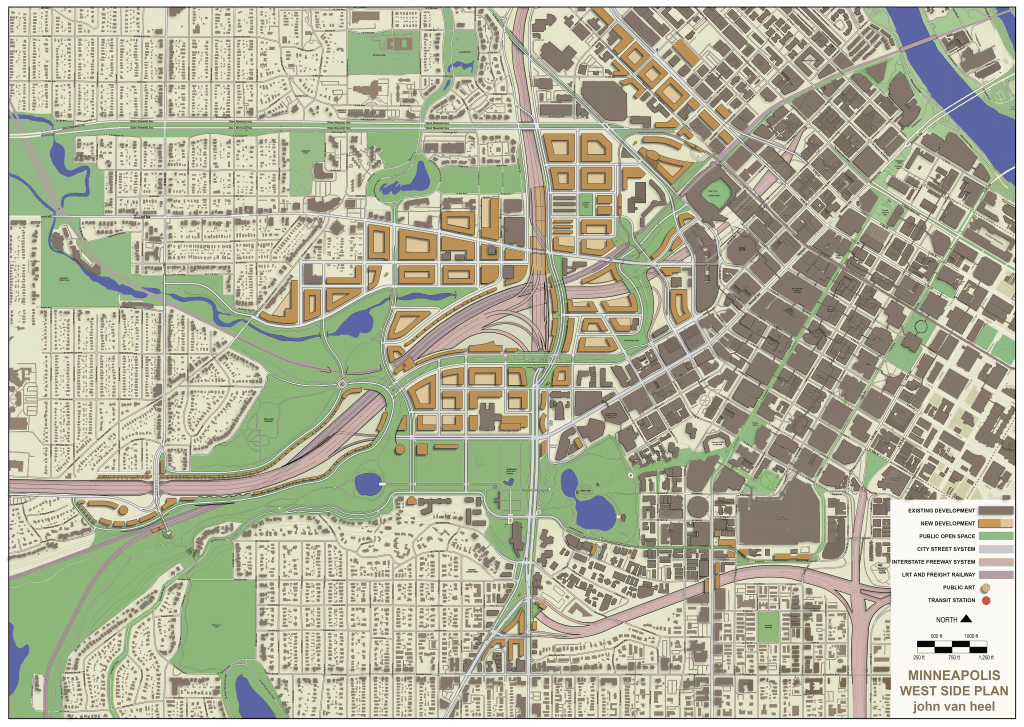
3. This plan assumes I-94 and I-394 will remain as major metro and state serving transportation arteries. Turning either into city boulevards will remain impractical.
4. The pedestrian paths shown in the plan are intended to show the presence of walking and bike paths. They are not specific to an actual layout.
5. The background plan of Minneapolis on which this concept plan was drawn shows streets to be narrower than they actually are. You will see transitions between the larger, more accurately scaled streets of the concept plan to smaller, less accurately scaled streets of the background plan.
6. Streets in the plan focus area are drawn with standard lane widths, but not all turn lanes and parking areas are shown.
7. The block structure for new development is intended to show typical building scale for residential and office structures with 60 to 80 foot building thicknesses, though some buildings are shown deeper. The building forms are intended to reinforce the street layout. Actual development would have more variation than shown.
8. Except for some freeway liner type development, most new development shown is intended to be high-density. This can be accomplished with mid-rise and or high-rise development. This plan is not intended to propose what kind of mix of heights might be built.
9. While a significant portion of new development shown in the plan is located on currently vacant land, there is also a significant amount of new development shown where there are existing buildings. The majority of these buildings are one and two-story industrial buildings. I have done my best to preserve buildings in the plan that appear to have historic significance. Of course, I am no expert. The plan would generally allow for further preservation of properties. The intent was to show the fullest extent of potential new development. I have stayed away from removing or replacing existing housing. However, I do show two houses in Bryn Mawr near I-394 being replaced by ‘garden wall freeway liner development’ houses and townhomes. As a concept plan, I did this to better illustrate this type of freeway liner development. No homes would need to be removed for the freeway realignment shown in the plan.
9. As a citizen vision (citizen, as in a member of the community) this plan has no client, no constraining jurisdictions, no confining scope. It is an exploration of possibilities – nothing more, nothing less.
